

We’ve been selling land since 2016, to more than 800 buyers, and we sell our own hunting tracts in Washington at McLaughlin Canyon Ranch, right up against public land. Most of this list came from walking those ridges with buyers, usually while one of us held a phone up looking for a signal.
Buying hunting land starts with a feeling. You see a ridge, a draw full of brush and one set of tracks, and your brain has already built the stand. The feeling is fine. The paperwork just needs to agree with it before you sign.
| What to check | Where to verify it | Why it matters |
|---|---|---|
| Legal access | Recorded easements in the title work | A dirt road isn’t a legal right to use it |
| Public land next door | BLM Public Lands Access map | Touching public land isn’t the same as reaching it |
| State trust land | Washington DNR, CPW trust land finder | Colorado trust land is closed unless enrolled |
| Game management unit | WDFW Hunt Planner, Colorado Hunting Atlas | Seasons and licenses follow the unit |
| Harvest history | WDFW harvest reports, CPW big game | Shows what hunters actually took |
| Landowner tag programs | CPW: 160 acres, WDFW: 1,000 acres | Small tracts don’t qualify |
| Boundaries | A licensed survey, then the county map | County maps aren’t surveys |
| Water and camp | Washington Ecology, Colorado DWR, the county | Camp needs water and county permission |
Eight checks, and not one of them is “did I see a big buck.” That one’s on the list too. It’s just not allowed to go first.
How do you check legal access to hunting land?
Legal access means a public road touches the land, or a recorded easement gives you the right to cross someone else’s land to reach it. Ask the seller or title company for the recorded easement and read who maintains the road. The track you drove in on doesn’t count until it’s on paper.
Rural roads have a way of looking official. Two ruts, a gate, a cattle guard, maybe a sign that says “Slow” in a font from 1974. None of that tells you whether you’re allowed to use it in November, or whether the neighbor can lock the gate in December.
Then check the road in the season you’ll actually hunt. Plenty of mountain roads are fine for a sedan in July and a firm no in January. Ask how far a 2WD truck gets in mud and snow, and who plows, if anyone. “Nobody, and the snow wins” is a real answer, and it’s better to hear it before closing.
Does land next to BLM land give you access to it?
Not by itself. Bordering public land lets you walk onto it from your own property, but the public may have no legal way in, and you can’t cross a neighbor’s land to get there. The Bureau of Land Management publishes a Public Lands Access map showing the legal places to enter BLM land through easements.
The BLM also points out that a mapped access point lets you cross to public land and nothing more. It doesn’t let you camp, hunt or park on the private ground in between. The landowner on that stretch would like you to keep walking, please.
This cuts both ways for a buyer. Public land with no public road in can be quiet, because few people can legally get to it. Public land with a highway trailhead can feel like opening day at a big-box store. Look at where the roads are before you fall for the acreage on the map.
Context helps here. In Washington, more than half the state’s land is privately owned, so public ground is the exception in a lot of valleys, not the rule.
Can you hunt state trust land next door?
It depends on the state. Washington’s Department of Natural Resources says its more than 3 million acres of state trust lands are accessible for hunting, with a Discover Pass on your vehicle. Colorado is the opposite: trust land is not open to the public unless it’s leased for public recreation.
In Colorado, nearly a million acres are open to hunting and fishing through the State Trust Lands access program, and the rest is closed. The State Land Board notes that hunting trust land without its permission is illegal under C.R.S. 33-6-116. A blue patch on a map app isn’t a permission slip.
So when a listing in Colorado says “next to state land,” ask which kind. One answer means elk. The other means a fine and a long talk with a wildlife officer who’s heard every version of “but the map was blue.”
How do you look up the game management unit?
Drop the property’s location into the state’s official map. In Washington that’s the WDFW Hunt Planner, which shows game management unit boundaries and regulations. In Colorado it’s the Colorado Hunting Atlas. Seasons, license types and limits all follow the unit.
Next, read the harvest numbers. WDFW publishes harvest reports by species, season and unit, and each district gets a hunting prospects report written by its biologist. They’re the closest thing to a trail camera you can check before you own the land, and they never get knocked over by a bear.
Okanogan County is a good example. In WDFW’s District 6 prospects report, GMU 204 (Okanogan East) runs from the Okanogan River east to the county line. It produced the most deer harvest in the district, it’s the only unit there with a significant number of elk, and it consistently produces the district’s highest black bear harvest.
A good unit is a reason to look, not a promise. Deer read none of these reports, and they move with snow, food and pressure. If elk are your focus in Washington, our guide to Washington elk hunting units and seasons goes deeper.
Does owning hunting land get you a tag?
Usually not. Owning land doesn’t change the season, the license or the draw. In Colorado, a limited number of licenses goes to each unit every year, and landowners compete in the same system unless they qualify for a landowner program.
Those programs are built for big places. Colorado’s Landowner Preference Program needs at least 160 contiguous acres of private agricultural land, in a unit where every rifle license is limited. Washington’s Landowner Hunting Permit program sets its minimum at 1,000 acres.
So on a 20- or 40-acre tract, plan to apply and buy licenses like everyone else. The upside is that your camp is already set up when the tag comes through. The downside is the draw doesn’t care how nice the camp is.
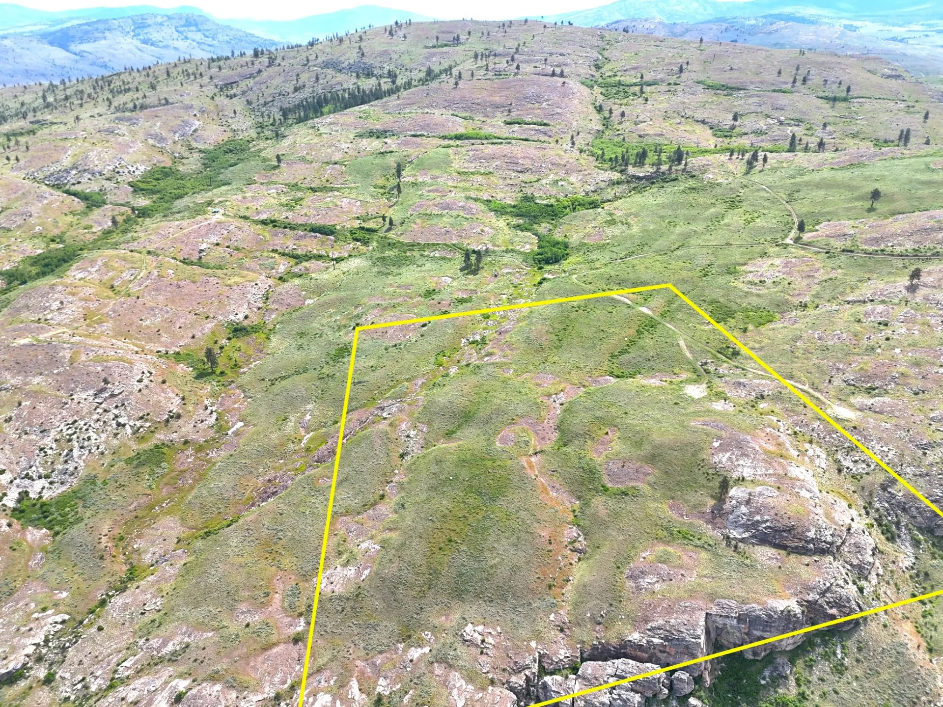
How do you confirm the boundaries before you hunt?
Get a survey, or a recent one from the seller, and walk the corners. County parcel maps are a starting point, not a boundary. Okanogan County’s own GIS map says it’s for evaluation purposes only and doesn’t represent actual surveyed boundaries.
That disclaimer is honest. Map lines get “adjusted for best fit,” which is a nice way of saying two maps disagree and nobody wants to referee. A parcel line that’s 50 feet off doesn’t matter much for a garden. It matters a lot when the deer you’re tracking crosses it.
Find the pins, flag them, and hang your stand a respectful distance inside. Our guide on how to find property corners and boundaries walks through it with a phone and a map. While you’re at it, look up the parcel on the FEMA flood map using our FEMA flood map guide, because the low ground that holds deer also holds water.
What about water and camping on hunting land?
Most hunting land is off the grid, so plan water, power and a legal place to sleep. You can haul water, catch it or drill a well, and the rules depend on the state. Camping and RV stays are set by the county, so ask before you plan a two-week camp.
In Washington, the groundwater permit exemption allows domestic use of up to 5,000 gallons a day, plus stockwater and up to a half-acre of lawn or garden, without a water right permit. In Colorado, a new well needs a permit from the Division of Water Resources, and its well permit search shows existing wells nearby.
Neither one guarantees water at the bottom of the hole. A well is a drilling bill with a surprise inside. Ask the seller for nearby well reports first, and price a hauled-water plan as your backup, because the backup is often the plan for the first season anyway.
On camping, rules swing a lot from county to county. One county lets you camp a couple of weeks without a permit. The next wants septic and a permit first. Read the county rule, then read it again on the night you’re tempted to stay “just one more weekend.”
Can you finance hunting land?
Yes. Bank loans on raw land vary a lot from lender to lender. Many land sellers, including us, offer owner financing, where you pay the seller directly over time. On our land the deed is recorded in your name at closing, and each lot page shows the down payment, monthly payment and term.
Whatever route you take, budget for the gear the land will ask for after closing: a gate lock, trail cameras, a road you’ll gravel one rut at a time. Land doesn’t send invoices. It just quietly breaks the cheapest thing in the truck.
What we’ve seen at McLaughlin Canyon Ranch and Trinchera Colony
We own and sell hunting and mountain land in two very different places, and each one taught us a few items on this list the hard way.
McLaughlin Canyon Ranch is an 890-acre mountain ranch about 15 minutes from Tonasket, in GMU 204. A private ranch road climbs from McLaughlin Canyon Road, graveled where it wears hardest, and we’ve hauled cabins all the way up it. The ranch borders 758 acres of BLM land that’s landlocked in the mountains and reached from that ranch road. That’s the access question from earlier, answered with a gate key.
Water there taught us humility. Ranch wells have come in anywhere from about 180 to 540 feet deep, one hole came up dry at around 300 feet, and a few tracts have springs instead. That’s why we hand buyers the well reports, and why the hardware store in Tonasket stocks big water tanks. Cell service is strong on top of the mountain and weak on the lower road, which is the opposite of where you’d want it when you’re stuck.
The road follows the seasons. A 2WD truck handles spring, summer and fall. Heavy rain and winter call for 4WD, and heavy snow calls for a snowmobile or your boots. A small herd of cattle grazes the mountainside, which keeps the grass down for fire season and keeps the land in agricultural use. The cattle also have strong opinions about the road, and they’re not shy about sharing them.
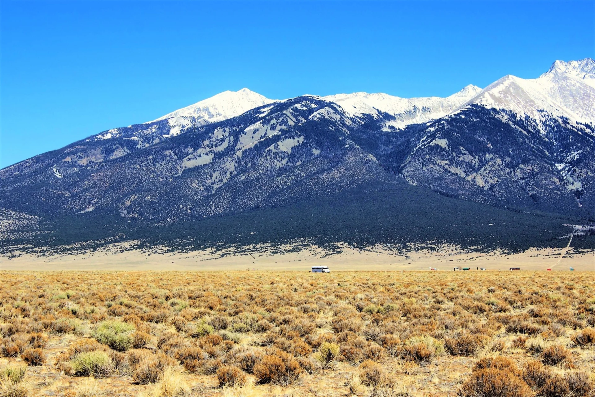
Trinchera Colony, in Costilla County, Colorado, sits in GMU 83, which has seasons for mule deer, elk, pronghorn, turkey and small game. The tracts run roughly 10 to 40 acres with county road access, about 5 minutes from Blanca and 20 from Alamosa. Blanca Peak sits almost straight ahead, which makes it hard to watch the brush line when you’re supposed to.
It’s off-grid camp country. Owners run solar, haul water from Alamosa or drill a permitted well, and area wells are commonly around 100 to 150 feet deep. Short-term RV camping is allowed up to 14 days in any 3 consecutive months without a permit. Longer stays, up to 180 days a year, need a county permit, a water source and an on-site septic system. For the wider valley, our San Luis Valley land-buying guide covers towns, water and building.
In both places the buyers who were happiest a year later had done the same boring thing first. They checked access, water and the unit before they picked out the stand. The stand turned out fine anyway. Stands usually do.
Ready to walk a ridge of your own? Browse our hunting land for sale, or see all land for sale in Okanogan County, and check each lot page for acreage, access and owner-financing terms.
Official resources
- Bureau of Land Management: Public Lands Access web map
- Washington Department of Fish and Wildlife: Hunt Planner webmap
- WDFW: Game Management Units
- WDFW: Game harvest reports
- WDFW: District 6 Hunting Prospects (Okanogan County)
- WDFW: Hunting Access on Private Lands
- Washington Department of Natural Resources: Recreation and hunting on state trust lands
- Washington Department of Ecology: Groundwater permit exemption
- Okanogan County: GIS map
- Colorado Parks and Wildlife: Colorado Hunting Atlas
- Colorado Parks and Wildlife: Big game hunting and licenses
- Colorado Parks and Wildlife: Landowner Preference Program
- Colorado Parks and Wildlife: State Trust Land Finder
- Colorado State Land Board: Public Access on Trust Land
- Colorado Division of Water Resources: Well Permitting
- FEMA Flood Map Service Center


